By recent standards, we really dropped into the lap of luxury here. We left the campsite at the Oregon Dunes NP, and were lucky enough to receive the hospitality of Christylee and Nicole, who are working as volunteers with the National Park Service this year. For some reason the service has vouchsafed them a splendid house with a spare bedroom. All this made a welcome change from the confines of our tent or tatty motel-dom. Not to mention the attentions of Christylee, who went well beyond the hostess's call of duty by using both her days off to lead us around and tell us huge amounts about everything and anything to do with Crater Lake National Park. From Nicole we learnt the call of the spotted owl and that there are absolutely, definitely, no doubt about it, no wolverines in the park. Thanks to both of you!
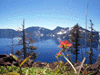
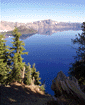
The lake is something that you never get tired of looking at. The water is incredibly blue, like something out of a tropical island holiday brochure. All around the rim are startling rock formations, the typical volcanic scenery. The volcanic process generates landscapes that comprise a mixture of very hard and very soft rocks, and as the latter erodes, fantastical shapes and colours emerging.
Outside the rims are the classic north-western pine and fir forests. Lots of wildflowers emerging when we were there added interest and colour, and made for pleasant walking in shady areas.
We had three days at Crater Lake. On the first day we climbed Garfield Peak and Mount Scott. The latter is the highest point in the park, and both provide spectacular views over the lake, for example as at left. Then it was off to Becky's diner for dins, and a splendid berry pie a la mode (that's American-French for "with ice cream", for all you confused Eurolinguists).
Day two we walked along Rogue River, away from the rim, amid lovely forest. For me the highlight of this was just the forest, but we did take in one interesting spectacle, which was a natural bridge. See the geology lesson at the side. In the evening we took a flower walk near the rim. The snow *still* lingers, six weeks late now, so the meadow is still a little less than blooming. Nevertheless, we did see a number of fine specimens, and with Christylee's aid, we achieved the unusual - for us - feat of actually knowing what flowers we'd seen.
Day three and we did the boat trip. It's a one mile hike down 700 feet to the lakeside. Then the boat takes around 45 minutes to wend its way across the lake's surface to Wizard Island. Throughout this day (in fact, throughout our stay) the sun shone, the sky was bright blue, and the lake even bluer. The patches of white snow made for a very vivid picture, and it's just as beautiful at close quarters.
Wizard Island is quite different, representing really quite 'recent' volcanic action. It's comprised largely of black rocks, looking as though they might have been coated in tarmac quite recently. The climb to the top reveals a small but deep crater, more wild flowers and some more fine views of the lake. It is 4 miles across in one direction and 6 miles across in the other and the combination of the blueness and the interesting shapes of the rim make it seem more beautiful the more you see it.
The highlight of the return boat journey was the "old man of the lake". This is a tree trunk that floats around the lake, oriented vertically so that just a few feet are visible above the surface. It's been doing this for at least the 100 years since it was first observed, and no-one's quite sure what makes it quite so stable.
Then off to see the pinnacles. More geology at the right. These are one of the wierdest things I've seen in a while, not really like anything else I can remember. Gray cones, towering perhaps 300 to 500 feet up, about 20 feet across and (so I'm told) hollow. It looks like the kind of structure that George Lucas might give a race of superintelligent termites to live in. Very still, rather sterile (not many toeholds for the weeds here) and just plain strange.
 Is the lake in a crater then?
Stuff comes out of the top of volcanoes. Usually this stuff originates in the magma chamber far below the surface. Now, if this magma chamber gets too empty, the top part of the mountain finds itself sitting on top of nothing, and eventually gravity catches up with it in spectacular fashion. The large hole that this leaves in the top of a mountain is known as a caldera.
In summary: a crater is actually a small hole at the top of a volcano that stuff has come out of: a caldera is a a large hole at the top of a volcano where stuff has fallen in. Needless to say, Crater Lake is a caldera, but it's ok, because there's a small island - Wizard Island - that does have a crater on top, and that crater is what the lake is actually named after.
 Why is the lake so blue?
Light rays go into water, and eventually get reflected back. The clearer the water, the further the light penetrates before being reflected. However, as the light passes through water, it gets scattered by water molecules, the lower frequencies first. The further into the water, the more of these lower frequencies get scattered, leaving only the higher (bluer) frequencies to make up the returning light.
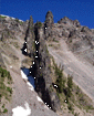 What's the devil's backbone?
The devil's backbone is a volcanic dike. A huge cloud of volcanic stuff goes up in the air, cools quickly and drops to earth as fairly light, porous and soft rock. Lave is forced up through the cracks in this rock, and because everything is still hot, cools very slowly. This allows the molecules to settle, the rock gets very dense, and you get walls of hard stuff amid the soft stuff. A lot of erosion later and you have a dike.
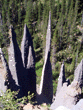 How about those pinnacles?
First a pyroclastic flow dumps the yellow stuff everywhere. Then a slower avalanche of molten rock adds the distinct grey layer. Finally, hot gas below seeking a vent comes up through cones called fumaroles. The rock immediately around a fumarole is exposed to great heat (400 degrees centigrade/750 fahrenheit) and fuses into something very strong indeed. The usual erosion strips everything else off exposing the cones. The really amazing thing about all this is that, as you'd imagine from this process, the fumaroles are often hollow!
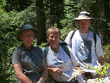 Natural bridges? [obviously not actually a bridge,
but as consolation here's a photo of us with our hostess, Christylee]
Natural bridges? [obviously not actually a bridge,
but as consolation here's a photo of us with our hostess, Christylee]
Lava flows down the hill. The bit on top cools first (touching the cool air not the hot ground), and solidifies, with the liquid lava still under it. The liquid bit flows out leaving a tube. Later water comes down the hill, into the tube, eventually erodes an exit and hey presto! natural bridge.