South from Canyonlands, we stopped off at National Bridges National Monument. Bridges are not the same as Arches. They both involve bits of rock with holes below, but the bridges are formed by erosion from flowing water whereas the arches are formed by erosion from rainwater. So completely different then.
The rest of the road to Capitol Reef is along highway 70, which is a good candidate for most picturesque highway in a state with many contendors. The road crosses both the Colorado and Dirty Devil rivers, provides a view of their confluence, and you get to marvel at the usual stunning south-central Utah rocks, only here they plunge directly into vast rivers.
And then Capitol Reef itself. On arrival, we discovered there was a slot canyon (what's a slot canyon? See the description on the Canyonlands page). Regular readers will be aware of how much we love these. What's more, the dirt road to this slot canyon is actually flat. And maintained. And positively un-life-threatening. So off we went, to "Sheets Gulch". More beautiful rock formations. This slot canyon had fairly recently been flooded, and still retained vast amounts of mud. The mud at different stages resembles molten chocolate gloop, then moves onto a second state where it's still gloopy but looks like sandstone rock and finally drys into what looks and breaks like pottery shards. Once you've trodden once in the gloop, and walked around with an extra few pounds of weight on your shoes for the next five minutes, you know not to do it again. Especially if you slid a couple of feet at first contact.
The rest of the time was spent admiring the rock formations. Capitol Reef has fascinating geology, but I do worry that it's only fascinating to those of us that don't have day jobs. So if you want to know, email us, otherwise we'll keep it to ourselves. Suffice it to say that there's a profusion of rock formations, including domes, cliffs, fins, layers, cross-beds, and they're all fascinating to gaze at.
One thing that is remarkable is the oasis called "Fruita" in the middle of the barren rocky landscape. This oasis is fuelled by the Fremont River, and was originally settled by Mormons who planted loads of fruit trees. The orchards are still functioning today, and it's all rather pleasant. The campground has a green lawn, the picnic area looks like Surrey in summer, whilst looming overhead are giant sandstone monoliths on which cactus eak out their existence.
Oh, and Butch Cassidy used to hide out in these parts. Given all the steep-sided canyons, dead ends and twisting rocks, I should think he could evade an army with ease.
After Capitol Reef, we drove on to Escalante.
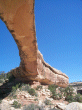
Natural Bridges National Monument
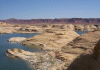
The Colorado River from route 92
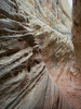
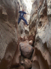
Sheets Gulch (our second slot canyon)